Stretching over 2,000 miles from the subtropical streets of Miami to the cold, rocky shores of Lake Superior, U.S. Highway 41 is one of America’s most fascinating north–south routes. It’s more than just a line on a map — it’s a cross-section of the country’s cultures, climates, and communities. From the Everglades to the Upper Peninsula, Highway 41 connects two worlds that could hardly be more different.
The Southern Beginning: Miami’s Tropical Edge
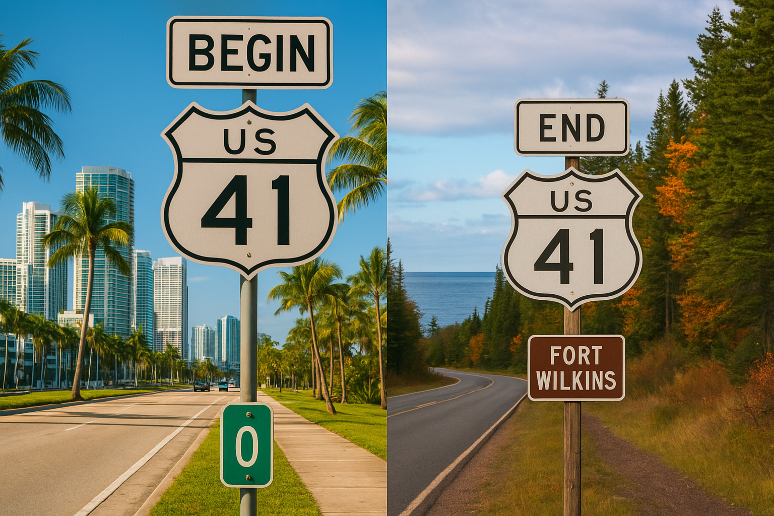
U.S. 41 begins in Miami, Florida, near the upscale Brickell neighborhood, where luxury high-rises meet Biscayne Bay. Palm trees line the boulevard, and the humid air buzzes with energy. This is a city that never truly slows down — filled with Cuban cafés, beachgoers, and the rhythm of Latin music.
Almost immediately after leaving downtown, the highway becomes known as the Tamiami Trail — a name blending “Tampa” and “Miami.” Built in the 1920s, it was once a daring engineering feat that carved a path straight through the Everglades. Today, travelers can still drive this two-lane stretch through sawgrass plains and mangrove swamps, sharing the roadside with alligators and herons.
Here, U.S. 41 embodies the essence of South Florida — hot, alive, and drenched in sunlight. You can sip on a cafecito, watch airboats skim the marshes, and feel the road pulse with tropical humidity. It’s an inviting start, filled with motion and life.
The Northern Finale: Copper Harbor, Michigan
Two thousand miles north, everything changes. The final stretch of U.S. 41 winds through the Keweenaw Peninsula in Michigan’s remote Upper Peninsula. Here, the road narrows, the traffic thins, and the pine forests deepen until the pavement seems to disappear into wilderness. The official end is at Fort Wilkins Historic State Park, just outside the tiny village of Copper Harbor, where Lake Superior stretches like an inland ocean to the horizon.
The atmosphere could not be more different from Miami’s: cool, misty air rolls off the lake, and the skyline is pine and granite instead of glass and steel. Locals gather in small diners to eat pasties — hearty meat pies brought over by Cornish and Finnish miners — and winters can bury the region under several feet of snow. The pace is slow, the quiet deep, and the sense of isolation profound.
Two Ends, One Road
U.S. 41 captures America’s geographic and cultural diversity in a single ribbon of asphalt. It connects tropical wetlands with northern forests, sprawling metropolises with small harbor towns. The differences between its two endpoints are striking:
| Feature | Southern End: Miami, FL | Northern End: Copper Harbor, MI |
|---|---|---|
| Climate | Tropical and humid | Cool, subarctic influence |
| Scenery | Beaches, palm trees, Everglades | Forests, cliffs, Lake Superior |
| Culture | Latin American, cosmopolitan | Finnish, Scandinavian, rustic |
| Vibe | Energetic, modern, hot | Quiet, remote, cold |
| Wildlife | Alligators, egrets | Moose, bears |
| Nearby Landmark | Biscayne Bay | Fort Wilkins / Lake Superior |
Driving the full length of U.S. 41 is like traveling through time and temperature — from coral limestone to copper ore, from mangroves to maples. Along the way, it passes through cities like Tampa, Nashville, Chicago, and Milwaukee, each adding a new layer of regional identity. It’s a highway of music (think “Route 41 Blues”), migration, and Midwestern grit — a route that feels both familiar and wild.
A Road Worth Remembering
While Interstate 75 has stolen much of its traffic, U.S. 41 still thrives as a scenic alternative for travelers seeking a slower, more authentic journey. Whether you’re chasing the sun in Florida or the northern lights in Michigan, the same highway will get you there — a continuous reminder of how vast and varied America truly is.

At one end, the roar of Miami traffic fades into ocean spray. At the other, the road simply stops at the edge of the continent, swallowed by pine trees and Superior’s wind. Between them lies the story of a nation told mile by mile.